Saturday, June 30, 2018

Fire Update from Washington County Emergency Services June 30

West Valley Fire Update
Date of Detection: June 27, 2018 Current Size: 7,724 acres Location: 10 Miles North of St. George Utah Legal Description: Latitude: 37∘ 23’ 50” Longitude: 113∘ 25’ 24” Cause: Human Caused Containment: 0% Resources on Fire: There are currently 321 personnel on this incident, including the following resources: Great Basin Team 6 assumed command of the West Valley Fire today June 30, 2018. CREWS TYPE 1 HELICOPTERS (HEAVY) TYPE 2 HELICOPTERS (MEDIUM) TYPE 3 HELICOPTERS (LIGHT) ENGINES 11 DOZERS 2 FIRE UPDATE – Great Basin Team 6 assumed command of the West Valley Fire today, June 30, 2018 at 0600, led by Incident Commander Brook Chadwick. The Incident Management Team is comprised of individuals from several agencies working within the Great Basin. This is a full-suppression fire and the objective is 100% containment. The top priority for the Incident Management Team is the safety of fire personnel and the public. The Incident Command Post (ICP) is located in Grass Valley. Firefighters made good progress yesterday. A crew of smokejumpers is working to secure the fire’s southern flank, or tail of the fire. Hotshot crews are constructing fireline directly on the fire’s edge where possible, working along the fire’s north and east flanks. Firefighters are being supported with helicopters dropping water on hotspots, and fixed-wing air tankers are available upon request. Hotshot Crews and Type 2 Initial Attack Crews are assessing structures about two miles from the fire’s north and west flanks, and clearing fuels along roads in the event that burning operations are necessary. No evacuations are in place. 
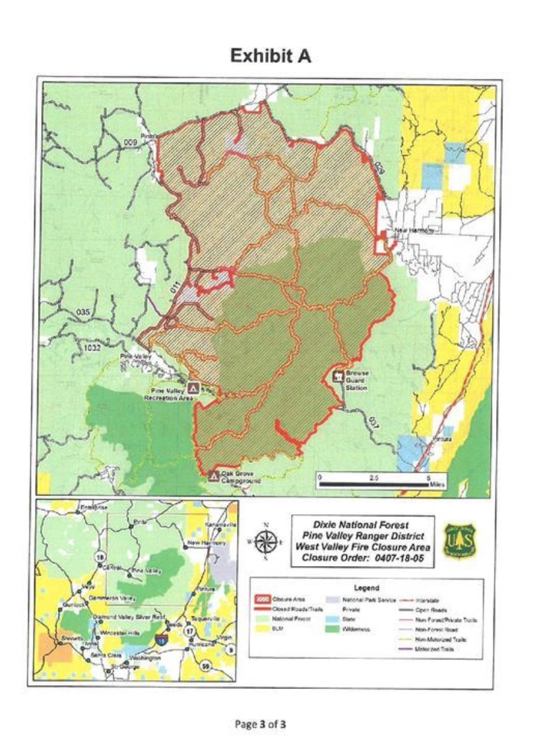
Emergency area, road and trail closures remain in effect. For details about these closures, please visit: https://inciweb.nwcg.gov/incident/article/5873/43533/ BACKGROUND—The West Valley Fire started on June 27 at approximately 5 p.m. The cause of the fire was an abandoned campfire. The fire is burning in mixed conifer, brush and grass. Fuel moistures are low, and the fire has been pushed by winds and steep terrain. FOR MORE INFORMATION: Facebook: @UtahWildfire and @USFSDNF, Twitter: @UtahWildfire and @USFSDNF, InciWeb: https://inciweb.nwcg.gov/incident/article/5873/43533/

Current Fire Information Posted in Front of the Fire Station

We haven't received any further updates on the fire situation today, but our fire chief would like residents to know that if they want the latest information, they can drop by the Pine Valley Fire Station on Main Street. There is a bulletin board in front that is updated as any new information comes in.

4th of July Celebration


Friday, June 29, 2018

Emergency Resources for Pine Valley


Following are three sources for emergency information that you should be aware of. Full time and part time residents should especially be signed up for the first in order to receive alerts by email, text or phone in the case of emergencies.

1. Washington County Utah Citizen Alert (Reverse 911): Everyone who has a home here should be connect to this system which will send alerts for emergencies and other important community messages. To sign up go to http://www.911register.com/

2. Pine Valley Blog: Updates on emergency situations as well as announcements about community events are posted on this community blog. The web address for the blog is http://pinevalleyblog.blogspot.com/    If you want to receive updates automatically by email, you can type your email address into the “Follow by Email” widget located on the right side of the page.

3. Nextdoor Pine Valley: This is an online social network just for Pine Valley where you can take part in community discussions as well as receiving information about events. To join Nextdoor, go to www.nextdoor.com/join   and use the code  NYXXQR 
The Washington County Utah Citizen Alert system will also be using the Nextdoor forum to contact us in the case of emergencies.

In an emergency situation, we are all safer if everyone knows what is going on.


Fire update from EM Coordinator Peter Kuhlmann, Washington County Emergency System

West Valley Fire Update
WEST VALLEY FIRE Pine Valley, Utah – The West Valley Fire saw significant growth yesterday, reaching approximately 7,200 acres in size. It remains at 0% containment. Fire investigators have determined the fire to be human-caused, from an abandoned campfire. The fire is being managed for full suppression. Yesterday, the fire burned aggressively to the northeast until it hit the Mill Flat Fire scar (from 2009). The decreased fuels in the old fire scar slowed the fire’s north-northeast progression. The fire continues to move slowly through that area. The community of New Harmony is not threatened at this time. A dozer, four engines, and two Type 1 handcrews are working in the New Harmony area, improving the existing fuel break and creating indirect line, should the fire push further in that direction. Smokejumpers are working near the origin of the fire, using direct attack to hold the south flank. There has been little to no growth near the anchor of the fire. There are no evacuations at this time and no structures imminently threatened. Approximately 10 homes on private land, near the Mill Flat Trailhead are potentially threatened; structure protection is in place as a precaution. These structures are located approximately 2 miles from the fireline. The Pine Valley Campground and Pine Valley Reservoir remain open. A temporary area closure has been put in place by the Dixie National Forest. The closure is from the Forest boundary west of New Harmony, and specifically lying west of Forest Road 029, the National Forest Boundary and the Pine Valley Wilderness Boundary, North of Pine Valley Wilderness Boundary, the Summit Trail and the Canal Trail, East of the Forest Road 011, and South of Forest Road 009. Forest Road 011 and Forest Road 035 to 4011 are closed. The Red Flag warning remains in effect until midnight on Saturday. This hot, dry and windy weather is expected to create containment challenges for firefighters. Aerial support was grounded most of yesterday due to strong winds. Aircraft remains available today, its use is dependent on favorable winds and safe flight conditions. Smoke will be highly visible throughout much of Iron and Washington Counties. West Valley Fire is located three miles northeast of Pine Valley Campground on the Dixie National Forest. It was reported on June 27, 2018. Resources assigned: Engines: 8 Handcrews: 6 Heavy Air Tankers: 3 Single Engine Air Tankers (SEAT): 4 Helicopters: 9 Air attack platforms: 2 Fire Managers have asked us to emphasize that they do not need any food or supplies. If people want to donate, Thank You notes for the firefighters are always appreciated. Or they can donate to their local Volunteer Fire Departments, who are all assisting with the fire. They can also donate money to the Wildland Firefighter Foundation.


Thursday, June 28, 2018

Update on Fire June 28, 2018


Update on the Fire from Peter Kuhlmann, Washington County Emergences Services

Wildfare Fact Sheet--West Valley Fire
Note: Get the latest fire updates on Twitter@UtahWildfire
Summary: The fire burned actively throughout the night and grew an estimated 500 acres. The fire will be mapped later this morning for a more accurate size. A national Type 2 Team is ordered and will bring more resources to the incident. A Red Flag warning is in effect for today and is expected to create containment challenges for firefighters. Smoke will be visible from most of Iron and Washington Counties. The fire investigation remains ongoing. Start Date: Wednesday, June 27, 2018- approximately 2:59 p.m. Location: One mile east of Gardner Peak, three miles northeast of Pine Valley Campground. Jurisdiction: Dixie National Forest, Pine Valley Ranger District. Fire Size: Estimated 2,500 acres (Note: one acre is equivalent to one football field) Cause: Under Investigation. Fire Behavior: The fire is currently active and is visible from multiple locations throughout Iron and Washington Counties. Closures: -Summit trail at the junction of browns point and oak grove is closed 31021 -Whipple trail 31025 -Browns point trail 31008 -Canal trail up on Gardner peak trail -Water canyon trail 31024 -Mill canyon 31013 -North summit 31021 -High line trail 31027 -Syler spring 31051 -Anderson trail 31022 -Comanche 31011 -Long flat 31050 -FS road 011 from grass valley to road 919 will be closed -White rocks trail 31014 -Rock springs trail 31019 Structures Threatened: Approximately 10 homes on private land, near the Mill Flat Trailhead, located three to five miles from the fire. Percent Contained: 0% Fuels: Timber, Mountain Brush, and Grass. Fire Crews/Resources: 8 Fire Engines, 6 Handcrews, 3 Heavy Airtankers, 2 Helitankers, 2 Helicopters, 4 Single Engine Air Tankers (SEATs), and 2 Air Attack Platforms are assigned. Five additional handcrews are ordered. Evacuations: No evacuations. Injuries: No injuries reported. For more information on fires in Utah visit www.utahfireinfo.gov.

Wednesday, June 27, 2018

Fire to the North


(Wednesday, June 27, 3:56 p.m.) There is currently a fire burning between Gardner Peak and Mill Flat. The BLM is aware of it and is taking charge of the situation. We will post further information as it becomes available.

There is no immediate danger and no structures are threatened. 

Tuesday, June 26, 2018

Locals water Monday through Thursday


Reminder--in addition to using 50% of our normal monthly water expenditure, locals are reminded to water on weekdays--M, T, W or Th. Part time residents who are usually here on weekends should water F, S or S. 

Spreading out water usage will help the tanks maintain the best level possible during this critically dry period. This will be especially important during July when so many people come to stay at their cabins. 

Monday, June 25, 2018

Simple Ways to Save Water

Dale Hagemeyer has shared the following ways to save water. At the end of the post, there is a link that you can use to print a copy if you would like to put one on your refrigerator or somewhere else to help you remember the tips.

Ways to Save Water Indoors                                                                                                                                 
·       Check all faucets, pipes and toilets for leaks.
·       Install water saving showerheads and ultra-low-flush toilets.
·       Take shorter showers. Rinse off, shut off, lather up, rinse off, shut off.
·       Never use your toilet as a wastebasket.
·       Turn off the water while brushing your teeth or shaving.
·       Defrost frozen food in the refrigerator.
·       Rinse vegetables in a full sink or pan of water.
·       Fully load your dishwasher.
·       Rinse dishes in a full sink or pan of water. Don let the water run while you load the dishwasher
·       Wash full loads of clothes.
·       Basically, never let the water just run at any sink.
Ways to Save Water Outdoors
·       Don't over-water landscaping.
·       Water your lawn or garden early in the morning or late in evening.
·       Adjust sprinklers so that they don't water the sidewalk or street.
·       Don't water on cool, rainy or windy days.
·       Equip all hoses with shut-off nozzles.
·       Use drip irrigation systems.
·       Plant drought-tolerant or low water-use plants and grasses.
·       Use shrubs and ground cover to reduce the amount of grass.
·       Place mulch around plants to reduce evaporation and discourage weeds.
·       Set your mower blades one notch higher, since longer grass means less evaporation.
·       Use a bucket instead of a hose to wash your car.
·       Use a broom rather than a hose to clean sidewalks or driveways.

Link for printable copy: https://drive.google.com/file/d/1sKv4I7KqJJ7vedOFei6Ip4rvLgUAsrJQ/view?usp=sharing


x